|
Introduction
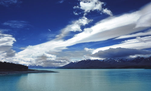
New Zealand (Aotearoa -- Maori for "Land of the Long White Clouds")
is located along the Pacific "ring of fire". Specifically, it lies on the
boundary between two great tectonic plates -- the Indo-Australian and the
Pacific. This is an area of the world characterized by active volcanoes,
geothermal activity, frequent earthquakes and mountain building that had a
profound effect on the country's size, shape, geography and geology.
Combine this with its weather and you get a country of rare scenic beauty
with lush green hills, rivers, sandy beaches and volcanoes in the north
and mountains, glaciers, lakes, and fjords in the south.
Statistics
x
Official name
The Dominion of New Zealand
Area
total: 268,680 sq km
about the size of Colorado or Japan
Coastline
15,134 km
Climate
temperate with sharp regional contrasts
Terrain
predominately mountainous with some large coastal plains
Elevation extremes
lowest point: Pacific Ocean 0 meters
highest point: Mount Cook 12,313 feet
Natural resources
sheep, natural gas, iron ore, timber, hydropower, gold, limestone
Population
3,819,762 (July 2000 est.)
Ethnic groups
New Zealand European 74.5%, Maori 9.7%, other European 4.6%, Pacific
Islander 3.8%, Asian and others 7.4%
Religions
Anglican 24%, Presbyterian 18%, Roman Catholic 15%, Methodist 5%, Baptist
2%, other Protestant 3%, unspecified or none 33% (1986)
Languages
English (official), Maori
Government type
parliamentary democracy
Capital
Wellington
|
|
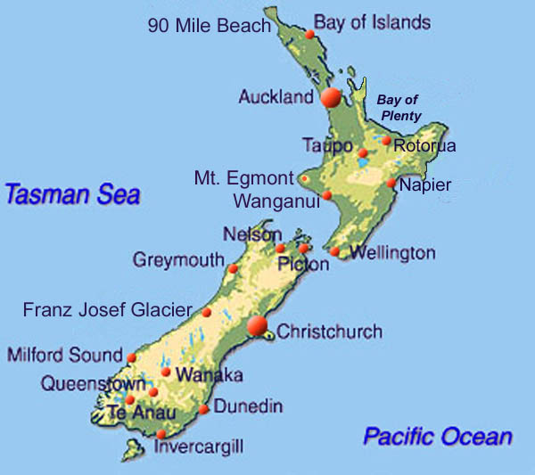
New Zealand lies 1600 km south-east of
Australia between the Pacific Ocean and Tasman Sea, extending from 33 to
53 degrees south latitude. It consists of two main islands -- North and
South, and a number of smaller ones with a combined area of 270,500 square
kilometers (similar in size to Japan). The main North and South Islands
are separated by the Cook Strait, which at its narrowest point is 20
kilometers wide.
The North Island is green, hilly and volcanic. In the north are
semi-tropical beaches (90 Mile Beach), the historic Bay of Islands where
Europeans first settled and North Point. Further south is the country's
largest city -- Auckland. The central portion consists of the volcanic
regions of Rotorua, Lake Taupo and Tongarariro National Park. Far to the
west is New Plymouth and the beautiful snow-capped volcano Mt. Egmont.
Most of he North Island is well watered and very green. The main rivers
are the Wakato and Wanganui. Near the islands southern tip is the capital
-- Wellington.
The South Island is more mountainous than the North. This is especially
evident along almost its entire length from near its west coast to its
center where the Southern Alps are found. Mt. Cook at 3,764 meters is the
highest peak. Many of these mountains have glaciers; the most famous are
the Tasman (length 29 kilometers), Murchison (17 kilometers), Fox (15
kilometers) and the Franz Josef (13 kilometers). The west coast is very
moist because of sea winds from the Tasman Sea. Close to the northern
section of the Southern Alps is Westland National Park and beautiful Lake
Matheson. The most southwesterly portion of the island is Fjordland
National Park which is home to magnificent Milford Sound. The park is very
mountainous, wet and indented by numerous glacially carved fjords.
However, the mountains form a barrier to the moist winds and the lands to
the east are drier. Several cyan-colored lakes are found in this region as
well as Lake Wakatipo and its lakeside resort, Queenstown -- gateway to
Fjordland. Along the east coast are the island's cities. The largest is
Christchurch in the north which is said to be the most English in New
Zealand. Also on the east coast but much further south is smaller Dunedin
which is Scottish in character.
Points of Interest
North Island
Northland
Northland (the most northerly region of New Zealand) is the cradle of both
Maori and Pakeha culture: it was here that the Pakeha (British) first made
contact with the Maori, the first whaling settlements were established and
the Treaty of Waitangi was signed. It has glorious sparsely populated
blonde beaches stretching nearly 100 miles on its west coast called the
Ninety Mile Beach. At the northern tip of the North Island is Cape Reinga
Lighthouse that looks out over both the Pacific Ocean and Tasman Sea.
Coromandel
The Coromandel Peninsula, east of Auckland, is steeped in gold mining
history, extinct volcanoes and is covered by temperate rainforest. Both
the east and west coasts of the peninsula has wonderful beaches.
Auckland
The largest city in New Zealand, Auckland (population 1,002,000) is almost
enclosed by water and covered in volcanic hills. Like Sydney, Auckland has
a spectacular harbour and bridge. Auckland now has the largest
concentration of Polynesians in the world. Highlights include the Auckland
Museum, which houses a memorable display of Maori artifacts. Panoramic
views of the city from the extinct volcano One Tree Hill, and good
swimming beaches including Kohimarama and Mission Bay.
Rotorua
Rotorua is a small town on the shores of Lake Rotorua. The surrounding
areas are a geothermal wonderland, with geysers, boiling mud pools, and
steaming craters - accompanied by the pervasive smell of sulphur. Rotorua
is also a showcase of Maori cultural activities and a center of tourism.
The Waikato River, Huka Falls and Lake Taupo (New Zealands largest) are
found south of Roturoa.
Urewera
Urewera National Park is located southeast of Rotorua and is the largest
forested wilderness area remaining on the North Island. It features dense
forests, waterfalls and Lake Waikaremoana.
Lake Taupo
Lake Taupo, New Zealand's largest lake at 600 square kilometers, is about
90 kilometres south of Rotorua. It was formed after a huge volcanic
eruption that took place some 1800 years ago. The volcanic crater then
filled with water, forming the lake. Situated over a thousand feet above
sea level it has a maximum depth of 500 feet. The lake is cold, full of
trout and often used for fishing and other water sports.
Tongariro National Park
Formally created by an act of parliament in 1894 Tongariro National Park
is New Zealand's oldest national park and a World Heritage area as well.
Found in central North Island just south of Lake Taupo are the three
andesitic volcanoes at the heart of the park -- Tongariro, Ngaruahoe and
Ruapehu. Together they form the southern limits of the Taupo Volcanic
Zone. Volcanic activity in the zone started about 2 million years ago and
is on-going today. Ruapehu and Ngauruhoe are two of the most active
composite volcanoes in the world.
Mt. Egmont
Mt. Egmont (Taranaki) is probably the most beautiful mountain in New
Zealand. It is similar to Mt. Fuji in Japan except that it has a very
green zone surrounding it. It is also one of the least visited areas in
New Zealand, because if its isolation on the western coast of the North
Island near the town of New Plymouth.
Whanganui River
The Whanganui (Wanganui) River and the national park of the same name
extends from central Tongariro to the west coast town of Wanganui. The
countryside is famous for its verdant scenery, forests and river rapids.
Raukawa Falls off highway 4 between Wanganui and Raetihi is one of New
Zealand's largest waterfalls.
South Island
Christchurch
This is the largest city on the South Island. It has many old style tudor
buildings and Hagley Park with its botanical gardens and Avon River.
Arthur's Pass
Driving west from Christchurch brings you into this mountainous region
with its verdant high pasture land and snow capped mountain peaks.
Punakaiki
Along the west coast north of Westland National Park is Punakaiki or
"Pancake Rocks". These amazing structures resembling stacks of pancakes
consist of limestone eroded by the force of the surf over years. When the
surf is right, blowholes can be seen.
Mt. Cook National Park
Mt. Cook at 3754 meters (12,313feet) is the highest mountain in New
Zealand and the main peak in the Southern Alps.
Westland National Park
Close to Mt. Cook is this park on the west central coast of the South
Island. Points of scenic beauty include Lake Matheson and the several
glaciers in the mountains (e.g. Franz Josef, Fox and Grey glaciers).
Airplane scenic flights with a landing in the high snowfields is a trip
you will never forget.
Queenstown
The beautiful South Island village of Queenstown is set in a glacial
valley on the edge of Lake Wakatipu. It is a town synonymous with tourism,
scenery and outdoor adventures. Not too far from this area are several
other beautiful lakes including Wanaka, Tekapo and Pukaki.
Fjordland National Park
Southwest of Queenstown is Fjordland National Park, which takes its name
from the fjords that indent its coast (see Doubtful Sound). It is a
wilderness of mountains, rainforests, waterfalls and glacier-carved
coastal sea inlets. The scenic climax of Fjordland is undoubtedly Milford
Sound where dolphins follow tour boats that cruise beneath the shadows of
towering mountains like Mitre Peak and pause by hanging waterfalls that
crash on to the calm waters of the Sound. There are also classic alpine
walks, including the Routeburn Track (in Mt. Aspiring National Park) and
the Milford Track (billed as the "finest in the world"). |
|
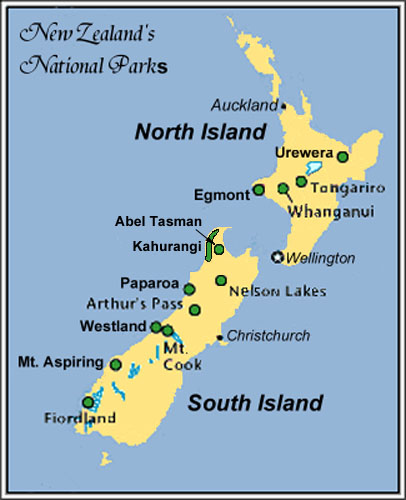
North Island Parks
Te Urewera National Park is a large forested
wilderness southeast of Rotorua on the North Island. Its prize attraction
is Lake Waikaremoana.
Tongariro National Park just south of Lake
Taupo, is New Zealand's oldest national park. The three andesitic
volcanoes at the heart of the park - Mounts Tongariro, Ngaruahoe and
Ruapehu form the southern limits of the Taupo Volcanic Zone. Volcanic
activity in the zone started about 2 million years ago and is on-going
today. A World Heritage Area, it contains lava flows, active craters, hot
springs, lakes, grasslands, and forests. Mt. Ruapehu is North Island's
highest peak and most popular ski resort.
Whanganui National Park lies between Egmont
and Tongariro National Parks and features mudstone cliffs, lush green
grasslands and forests. The 105-mile Whanganui River affords an
extraordinarily scenic canoe trip. Beautiful Raukawa Falls can be seen off
Highway-4 between the towns of Wanganui and Raeti.
Egmont National Park near New Plymouth of
North Island's mid West Coast encompasses Mount Taranaki (Egmont). This is
a large conical volcano reminescent of Japan's Mt. Fuji. Egmont has
erupted at least eight times in the last 6,000 years. Most of these
eruptions have been explosive and from the central vent. Two flank
eruptions produced Fanthams Peak and Southern Beehive about 1,300 years
ago. The last eruption of Egmont was in 1755. The terraine in the park
extend from black sand beaches to lowland rainforest, through alpine
fields, and snow capped summit.
South Island Parks
Abel Tasman National Park, located on Tasman
Bay at the very top of the South Island, is the smallest of New Zealand's
national parks. Its four-day walking track skirts a beautiful secluded
coastline of unspoiled, golden-sand beaches and rocky coves, set against a
backdrop of forested hills.
Kahurangi National Park is northwest of the
city of Nelson and west of the smaller Abel Tasman National Park It is the
newest (1996) and second largest national park in New Zealand. It is a
large wilderness park with mountains, rivers, lakes, karst land forms,
forest, alpine fields and western coastline. Home of the Heaphy Track,
walkers on this track will follow the northwest coastline and pass through
a palm forest, rainforests and high country before descending to Golden
Bay east of the park.
Nelson Lakes National Park, south of Nelson,
is noted for its alpine flowers and is the perfect place to explore craggy
ranges, crystal-clear lakes, wild rivers and beautiful beech forests.
Paparoa National Park was recently
established to protects the karst (eroded limestone) environment
surrounding Punakaiki ( "Pancake Rocks" ) north of Greymouth. Here the
stratified limestone coastal "Pancake Rocks" interact with the surf to
produce blow holes and waterspouts. Inland trails lead through a limestone
country of caverns, canyons and rivers.
Arthur's Pass National Park lies 140 km west
of Christchurch. The Pass is one of the three across the Southern Alps
carrying roads which link the west and east coasts of the South Island.
The most northerly is the Lewis Pass, Arthur's Pass is in the middle and
Haast Pass is to the south. European history begins with the discovery of
the Pass by Arthur Dudley Dobson in 1864 but little interest was shown in
it until gold was discovered on the west coast. Later a railway as built
accross it and in 1926 Arthur's Pass National Park, the first in the South
Island was created. The Park includes 16 named peaks over 2000 meters, the
highest being 2,400 meter Mt. Murchison and the most accessible is Mt.
Rolleston at 2,271 meers. There are two major rivers with headwaters in
the Park, the Waimakarriri which flows across the Canterbury Plains to the
Pacific Ocean in the east, and the Taramakau which flows into the Tasman
Sea in the west. From its towering mountains to its rainforests, it can be
viewed either from your car or from the big windows of New Zealand's most
memorable train -- the TranzAlpine.
Westland National Park on the West Coast of
the South Island is where mountains and glaciers blend into coastal
rainforests before meeting the sea. Don't miss serene Lake Matheson with
its mirrored view of the Southern Alps.
Mount Cook National Park straddles the
Southern Alps and includes 22 peaks over 10,000 feet. The tallest is Mount
Cook at 12,317 feet
( 3754 meters).
Mount Aspiring National Park features Mount
Aspiring, often called the Matterhorn of New Zealand. The park offers some
of the best hiking in New Zealand.
Fiordland National Park is bigger than the
rest of the other parks combined. Its vast wet area includes extensive
walking tracks, lakes, rainforests and mirror smooth fiords like famous
Milford and Doubtful Sounds. |